
- DRECP Gateway |
- Datasets |
- California Fish Passage Assessment Database (May 2014)
California Fish Passage Assessment Database (May 2014)
Nov 24, 2014
(Last modified Jun 7, 2019)
Uploaded by
Conservation Biology Institute
This item is included in Data Basin, but has not been added to the DRECP Gateway.
- Description:
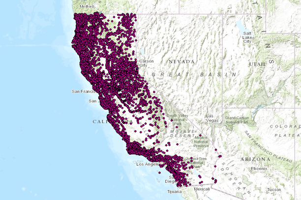
- The Passage Assessment Database shapefile contains locations of known and potential barriers to salmonid migration in California streams with additional information about each record.Preferred citation: California Department of Fish and Wildlife, Passage Assessment Database, May 2014 Version
- Data Provided By:
- Pacific States Marine Fisheries Commission, Anne Elston, Data Management Specialist for the PAD
- Content date:
- 20140521
- Citation:
-
P:\WorkArea\ds001-099\069-PassageAssessmentDB\v22\v22_work\ds69.gdb\ds69
http://bios.dfg.ca.gov/
ftp://ftp.dfg.ca.gov/BDB/GIS/BIOS/Public_Datasets/001_099/ds069.zip
www.calfish.org
- Contact Organization:
- Pacific States Marine Fisheries Commission
- Contact Person(s):
- Use Constraints:
- None
- Layer:
- Layer Type:
- Currently Visible Layer:
- All Layer Options:
- Layers in this dataset are based on combinations of the following options. You may choose from these options to select a specific layer on the map page.
- Description:
- Spatial Resolution:
- Credits:
- Citation:
- Purpose:
- Methods:
- References:
- Other Information:
- Time Period:
- Layer Accuracy:
- Attribute Accuracy:
FGDC Standard Metadata XML
Click here to see the full FGDC XML file that was created in Data Basin for this layer.
Original Metadata XML
Click here to see the full XML file that was originally uploaded with this layer.
This dataset is visible to everyone
- Dataset Type:
-
Layer Package
Bookmarked by
3 Groups
Included in
1 Public Map
,
4 Private Maps
Included in
4 Public Galleries
About the Uploader
Conservation Biology Institute
We provide advanced conservation science, technology, and planning to empower our partners in solving the world’s critical ecological challenges